A Comprehensive Guide to Hyperspectral and Multispectral Drones
Welcome to the exciting world of Hyperspectral and Multispectral Drones! This guide is designed to give beginners an in depth look into these advanced drone technologies, explaining how they work, their importance, practical use cases, and notable providers.
Table of Contents
What Are Multispectral Drones?
Multispectral drones are specialized unmanned aerial vehicles (UAVs) equipped with multispectral sensors that capture images across multiple wavelengths of light, including visible (red, green, blue) and non-visible (near-infrared, red-edge) spectrums. These drones collect data by capturing light reflected off objects in these different bands, which can then be analyzed to extract valuable insights about the environment, vegetation, soil, and other elements.
How Multispectral Technology Works
- The multispectral sensor on the drone captures images in multiple specific wavelengths simultaneously as it flies over an area.
- Each wavelength corresponds to a specific "band" that reveals different details about the scanned objects or areas. For example:
- Visible light bands help capture images similar to what we see with our eyes.
- Near-infrared (NIR) is used to detect plant health since healthy plants reflect more infrared light.
- The collected data is processed into maps or models that provide insights about vegetation health, soil composition, water stress, and more.
Common Applications of Multispectral Drones
- Agriculture:
- Monitoring crop health: Identify stressed plants, nutrient deficiencies, or water stress.
- Precision agriculture: Manage fields more effectively by applying only fertilizers, pesticides, or water where needed.
- Yield estimation: Estimate crop yields by monitoring growth stages and health.
- Forestry:
- Tree health assessment: Detect early signs of disease, pest infestations, or nutrient deficiencies in forests.
- Forest management: Monitor forest density, species distribution, and growth patterns.
- Water Management:
- Detecting algae blooms: Identify areas with algae growth or water pollution.
- Monitoring water quality: Track changes in water bodies, like lakes and reservoirs, to detect sediment levels or pollutants.
Industries That Benefit from Multispectral Imaging
- Agriculture: Farmers and agronomists use multispectral drones for crop management, resulting in better yields and resource optimization.
- Forestry: Forest managers monitor forest health, plan harvesting operations, and manage natural resources.
- Environmental Management: Conservationists track the health of ecosystems, detect changes in vegetation, and monitor water bodies.
- Mining: Multispectral drones assist in vegetation restoration, monitoring, and evaluating the impact of mining activities on the surrounding areas.
By capturing detailed data across different light spectrums, multispectral drones provide actionable insights, making them valuable tools across various industries, particularly for monitoring and managing natural resources.
What Are Hyperspectral Drones?
Hyperspectral drones are advanced unmanned aerial vehicles (UAVs) equipped with hyperspectral sensors that capture detailed images Across an extensive range of wavelengths in the electromagnetic spectrum. Unlike standard cameras or multispectral sensors, hyperspectral technology collects data in hundreds of narrow, contiguous spectral bands, providing highly detailed information about the composition and characteristics of objects or surfaces being scanned.
How Hyperspectral Technology Works
- Hyperspectral sensors capture light across a broad spectrum, from visible to near-infrared, often splitting the spectrum into hundreds of narrow bands.
- Each pixel in a hyperspectral image contains the full spectrum of data, allowing for the identification of unique "spectral signatures" of different materials or substances.
- By analyzing these signatures, it's possible to identify, classify, and monitor the characteristics of objects with high precision, such as distinguishing between different plant species or detecting minerals.
Key Differences from Multispectral Imaging
- Number of Bands: Hyperspectral sensors capture data in hundreds of bands, while multispectral sensors capture only a few (typically between 3 and 10).
- Data Detail: Hyperspectral imaging provides much more detailed information, allowing for the identification of subtle differences in materials, vegetation health, or soil composition.
- Data Complexity: Hyperspectral data is more complex and requires advanced processing techniques, making it more suitable for high-precision applications.
Applications of Hyperspectral Drones
- Precision Agriculture:
- Crop health analysis: Detect subtle differences in plant health, nutrient deficiencies, or water stress.
- Species identification: Differentiate between plant species or even identify weeds, pests, or diseases in crops.
- Soil analysis: Identify variations in soil composition, moisture levels, and fertility.
- Mining:
- Mineral exploration: Identify and map the distribution of minerals and ores based on their spectral signatures.
- Monitoring rehabilitation: Assess vegetation regrowth and soil quality in rehabilitated mining areas.
- Environmental Studies:
- Monitoring ecosystems: Track changes in vegetation, detect invasive species or monitor forest health.
- Water quality assessment: Identify pollutants, sediment levels, and algae growth in water bodies.
Industries That Benefit from Hyperspectral Imaging
- Mining: Hyperspectral drones help in mineral exploration by accurately identifying minerals on the surface, leading to more efficient exploration and mining operations.
- Agriculture: Farmers use hyperspectral data to detect crop stress, optimize input usage, and improve yield predictions.
- Environmental Management: Conservationists monitor ecosystems, assess vegetation health, and detect environmental changes more accurately.
- Infrastructure Inspection: Hyperspectral imaging can detect material degradation, corrosion, or structural issues in buildings, bridges, and other infrastructure.
Hyperspectral drones offer unparalleled detail and accuracy, making them indispensable in industries that require high-resolution, data-rich insights for monitoring, analysis, and decision-making.
Multispectral vs. Hyperspectral: Key Differences
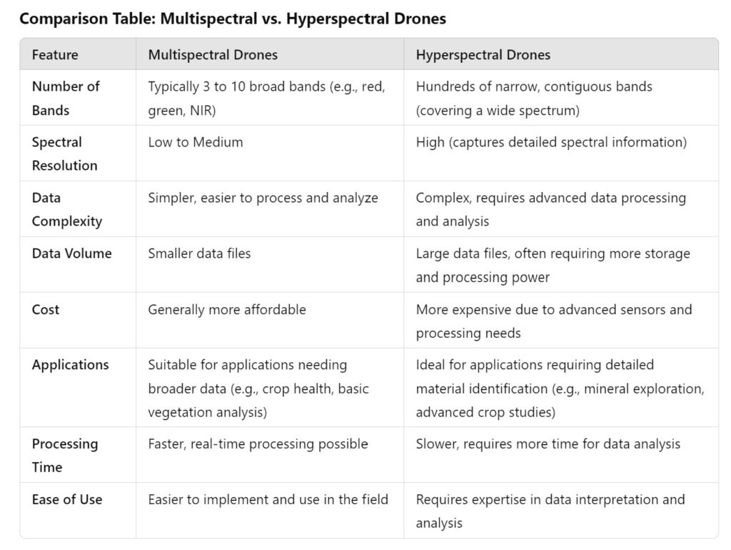
Multispectral and hyperspectral drones are powerful tools for remote sensing, but they differ significantly in data capture, complexity, and applications. Below is a comparison table highlighting the differences between the two technologies, followed by guidance on when to use each type.
Comparison Table: Multispectral vs. Hyperspectral Drones
When to Use Multispectral vs. Hyperspectral Drones
Use Multispectral Drones When:
- You need to monitor vegetation health, such as in agriculture, forestry, or water management.
- You aim to identify broader patterns (e.g., overall crop health, water stress, or detecting diseased areas in a field).
- Budget is a concern, and you require a more affordable solution.
- Quick, real-time insights are needed, and you want to process data efficiently in the field.
Use Hyperspectral Drones When:
- You need to identify specific materials or substances with high precision (e.g., detecting mineral compositions, differentiating plant species, or identifying pollutants).
- You require detailed, high-resolution data for research, environmental studies, or precision agriculture.
- You have the expertise and resources to handle complex data processing and analysis.
- The project requires in-depth analysis that goes beyond what multispectral data can provide.
In summary, multispectral drones are best for applications that require broader, easier-to-interpret data, making them suitable for general monitoring tasks. In contrast, hyperspectral drones excel in applications demanding high-resolution, detailed spectral information, making them ideal for more specialized, data-intensive projects.
Applications of Multispectral and Hyperspectral Drones
Multispectral and hyperspectral drones offer various applications across different industries because they capture detailed and valuable data from various environments. Here’s how they are used in key sectors:
Agriculture
- Crop Health Monitoring (Multispectral Drone Agriculture):
- Multispectral drones are widely used in agriculture to monitor crop health. They can detect stress factors, nutrient deficiencies, pests, and diseases by analyzing how the plants reflect different wavelengths of light.
- Precision Farming:
- Multispectral and hyperspectral drones help farmers implement precision farming techniques by providing detailed information on crop growth patterns, soil conditions, and moisture levels. This data enables targeted application of fertilizers, pesticides, and water, optimizing yields and reducing costs.
Forestry
- Tree Health Assessment (Multispectral Imaging):
- Multispectral drones are useful in monitoring tree health and growth, identifying disease outbreaks, pest infestations, or drought-affected areas.
- Disease Detection (Hyperspectral Imaging):
- Hyperspectral drones can detect subtle differences in vegetation health, allowing forest managers to identify diseases or stress factors affecting specific tree species, even before symptoms become visible to the naked eye.
Environmental Monitoring
- Water Quality Analysis (Environmental Monitoring with Drones):
- Multispectral and hyperspectral drones are used to monitor water bodies for changes in water quality, such as detecting algae blooms, sediment levels, or pollution. They can identify variations in water temperature, chlorophyll content, and suspended particles.
- Pollution Tracking:
- Hyperspectral imaging is particularly effective in identifying pollutants in water and soil and monitoring changes in vegetation affected by environmental contaminants.
Mining
- Mineral Detection (Hyperspectral Drone Mining):
- Hyperspectral drones are invaluable in the mining industry for mineral exploration. They can identify and map the distribution of minerals based on their unique spectral signatures, making it easier to pinpoint areas with high mineral content.
- Soil Composition Analysis:
- Multispectral and hyperspectral drones can analyze soil composition, helping mining companies assess potential extraction sites and monitor the impact of mining activities on surrounding environments.
These applications demonstrate how multispectral and hyperspectral drones provide valuable insights across industries, helping optimize processes, reduce costs, and improve decision-making in agriculture, forestry, environmental monitoring, and mining.
How do they work?
Multispectral and hyperspectral sensors work by capturing light that is reflected off objects. Different materials reflect light differently, and these differences can be measured and categorized into spectral signatures.
By comparing these signatures with known profiles of different materials, it's possible to identify and map the distribution of various elements in the surveyed area. For example, different vegetation types reflect light differently, allowing these sensors to distinguish between various plant species and identify water stress, disease, and more.
Why are they Important?
Hyperspectral and multispectral drones offer unique advantages over traditional imaging methods:
- Detailed Analysis: They provide detailed information about the surveyed area that can't be obtained through standard RGB imagery.
- Remote Sensing: They can safely and remotely gather data from inaccessible or hazardous areas.
- Efficiency: They can cover large areas quickly, making them more efficient than ground-based survey methods.
Use Cases and Examples
- Agriculture: Multispectral and hyperspectral drones can help identify crop health, monitor growth, detect pests and diseases, and optimize irrigation systems.
- Environmental Monitoring: They can monitor environmental changes, assess water quality, track wildlife, or study plant health.
- Mining and Geology: These drones can detect minerals, study geological formations, and aid exploration.
- Infrastructure Inspection: Drones can detect wear and tear, rust, or other potential issues in a variety of types of infrastructure such as bridges, roads, and buildings.
- Forestry: They can help in forest management by assessing tree health, species identification, and tracking deforestation.
Providers of Hyperspectral and Multispectral Drones
Several companies provide drones equipped with hyperspectral and multispectral sensors:
- MicaSense: MicaSense provides advanced multispectral camera sensors designed specifically for drone use. Their sensors are widely used in agricultural drone applications.
- Headwall Photonics: Headwall Photonics offers a range of hyperspectral imaging sensors suitable for UAVs, covering various spectral ranges.
- Specim: Specim provides hyperspectral imaging solutions, including airborne systems for drone integration.
- DJI: DJI, a leading drone manufacturer, offers drones with multispectral sensors like the DJI P4 Multispectral.
- Parrot: Parrot offers the ANAFI USA drone with a multispectral sensor for precision agriculture.
In conclusion, hyperspectral and multispectral drones are powerful tools, providing unique insights across various industries. As a beginner, understanding the potential of this technology is a crucial step in utilizing it to its fullest. Happy exploring!
Drone Guides
Drone Industry Articles
Maximizing Tax Savings: Section 179 for Drone Service Providers
Understanding Section 179 for Drone Service Providers As a drone service provider, staying ahead in a competitive market often requires…
Read More16 Unique Agricultural Spray Drones Uses Revolutionizing Modern Farming
16 Unique Agricultural Spray Drone uses Revolutionizing Modern Farming In recent years, agricultural spray drones have rapidly transformed the landscape…
Read MoreInnovations in Precision Agriculture: The Emergence of Drone Technology in Planting
The agricultural sector is poised for a technological revolution, with drone innovations marking a pivotal shift in farming methodologies. Specifically,…
Read MoreThe Role of Drones in Precision Agriculture: Elevating Farming Efficiency to New Heights
Precision agriculture marks a paradigm shift in how farming approaches, moving from traditional, broad-scale strategies to highly efficient, data-driven methodologies.…
Read More11 Ways Drones are Revolutionizing Agriculture
The incorporation of drone technology into the agricultural sector represents a significant transformation in farming methodologies, encompassing crop cultivation, monitoring,…
Read MoreDrone Vendor Articles
Implementing Leasing Incentives into marketing for commercial UAV vendors
Leasing Sales Strategies for UAV Vendors Leasing incentives can be an effective way for commercial drone dealers to promote their…
Read MoreWhat Marketing Channels Should Drone Dealers use to offer financing
5 Ways Drone Dealers can Market Financing Options to their customers Commercial drone dealers can offer Financing through various marketing…
Read MoreHow Drone Vendors can Increase Quote to sale conversions
How to Commercial Drone Vendors can increase quote to sale conversions Commercial drone dealers can increase quote to sale conversions…
Read MoreDrone Vendor Website Application
Reasons Commercial Drone (UAV) Dealers should offer financing on their website Commercial drone dealers should consider offering Financing on their…
Read MoreDrone (UAV) Vendor Financing
Financing can be a powerful tool for commercial UAV dealers looking to grow their businesses and improve customer satisfaction. It…
Read MoreDrone Financing Programs
Real Estate Photography and Videography Drone Financing
Real Estate Photography & Videography Drone Financing & Leasing Real estate agencies need high-quality photos and videos to market their…
Read MoreEngineering Drone Financing and Leasing
Engineering Drone Financing and Leasing Drone technology has been a game-changer for engineers. Through the use of drones, engineers can…
Read MoreRoofing Drone Financing and Leasing
Roofing Drone Financing and Leasing Roof inspections can be time-consuming, challenging, and even dangerous. Fortunately, technology has offered a better…
Read MoreDrone LiDAR Sensor Financing and Leasing
Drone LiDAR Sensor Financing and Leasing A Light Detection and Ranging (or LiDAR) sensor emits light energy to scan the…
Read MoreInspection Drone Financing and Leasing
Inspection Drone Financing and Leasing There are a number of industries that require regular visual inspections as part of their…
Read MoreStartup Business Commercial Drone Financing & Leasing
Startup Business Commercial Drone Financing and Leasing Start a Drone Service Business Today with Financing and Leasing options for your…
Read More